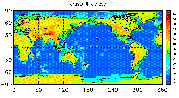
The global crustal model uses a type key to assign crustal
structure at a 5 x 5 deg scale. Data were gathered from
seismic experiments and averaged globally for similar
geological and
tectonic settings
(such as Archean,
early Proterozoic, rifts etc.).
These averages were used to
assigned structure to regions without seismic information
(e.g. most of Africa, South America).
Ice and
sediment thicknesses
where gathered from published
maps. Bathymetry and topography is that of ETOPO5.
The global model is composed of 139 key 1d-profiles (the
crustal types) where one of these profiles is assigned
to each 5 x 5 degree cell.
Each individual profile is a 7 layer 1D-model with
Seismic tomography has been extensively used in various forms to determine the three-dimensional velocity structure of the Earth's mantle. The data used in these studies are surface wave (waveforms and dispersion measurements) and free oscillation (frequency shift) data as well as body wave travel times (arrival times from catalogues such as the ISC catalog and specially hand-picked long-period arrivals). For the majority of these studies, the crust has a significant impact on the observed seismic data but, at the same time, is too thin to be resolved by them. Most authors handle this by applying an assumed "crustal correction" to the data before an inversion for mantle structure. Since the inversion techniques can erroneously map crustal structure down to great depth (at least 250km), accurate crustal corrections to the data sets are extremely important.
Another aspect is the seismic monitoring of nuclear explosions. Key elements of
the monitoring effort are location and size estimation. The location accuracy
strongly depends on the chosen velocity model (i.e. crustal structure),
especially when seismic sources lie
outside the monitoring network.
Monitoring on regional scale includes the modelling
of short-period surface waves and the propagation of Lg waves
which are very sensitive to variations of crustal structure.
Obviously, an accurate image of the Earth's crust would tremendously improve
the understanding of wave propagation of such phases.
Further info is available at the USGS site.
Goto REM web page
Goto Gabi's Home page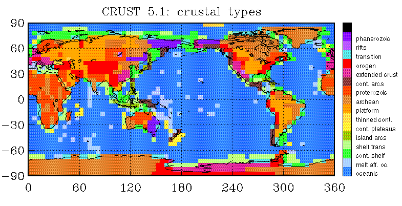