Frequently Asked Questions

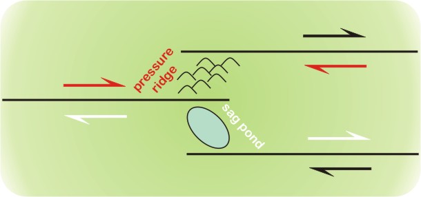
A fault step is defined as a region where the fault is not linear but instead is discontinuous and takes a ‘step’ either to the right or to the left of its original trend. Fault steps generally create local zones compression (pressure ridges, or mountains) or extension (sag ponds). Importantly, in an area with a fault step, the main trace of the fault does not change trend. It merely "steps" over, sideways, and continues along a similar trend. For this reason, fault steps are typically small-scale features, and their effects are limited to the immediate area near the step-over.
Convergent steps can create compression and easily identified uplift, yet geologists often find important value in divergent steps. These divergent fault steps often create small "pull-apart" basins and sag ponds in which organic material, which can be radiocarbon-dated, piles up. When a major rupture happens, these sediments can be cut and offset, then overlain by more sediment, until the next rupture cuts those. In this manner, a chronological record of major ruptures can be preserved. Paleoseismology is a field that looks into pre-historic earthquakes, and investigating such sequences of rupture records in sediment is one of that field's key research methods.
Information modified from: http://www.scec.org/education/public/allfacts.html
Image from: http://blogs.agu.org/mountainbeltway/files/2010/12/stepover2.jpg
Q: What is a step-over zone?

• The volume of Lake Cahuilla at it’s fullest is approximately: ~240 cubic kilometers.
• What this means is that it’s volume is somewhere between the size of Lake Tahoe (150 cubic kilometers) and Lake Erie (484 cubic kilometers).
• The weight is therefore about 265 Gtons (US).
• The volume of the Salton Sea is ~9 cubic kilometers, which is about the same as the San Francisco Bay.
-
•In english units, the volume of Lake Cahuilla is ~57 cubic miles, and the volume of the Salton Sea is ~2 cubic miles.
Q: How big is the Salton Sea?
Back-of-the-envelope calculations to give a sense of scale


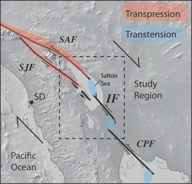
Q: Within your study area is there mostly ‘transpression’ or ‘transtension’?

Both transpression (regions in red) and transtension (regions in blue) exist within our study area.

Q: Is the San Andreas fault the only fault near the Salton Sea?
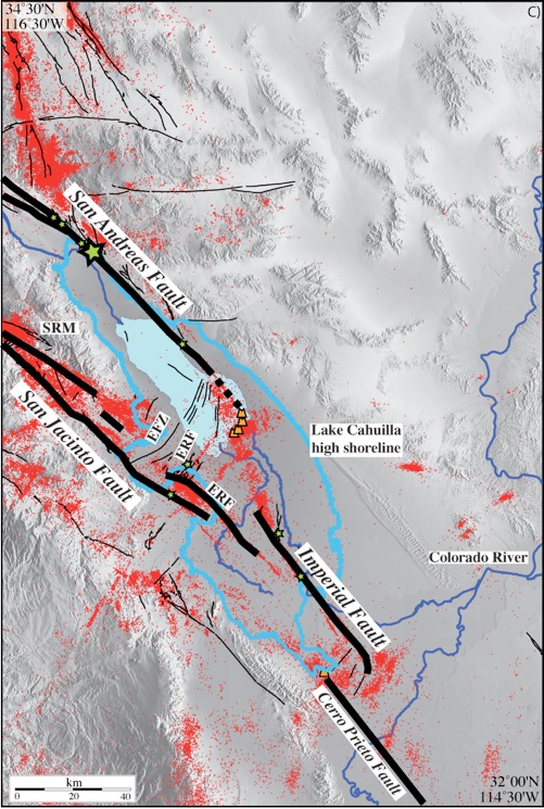
Multiple faults (labeled black lines) comprise the
tectonic plate boundary near the Salton Sea.

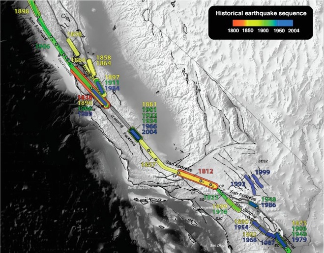
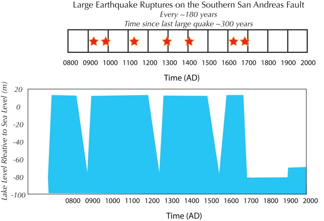
Q: What portions of the San Andreas Fault have ruptured since 1800?
Instrumental recordings of earthquakes started in approximately 1900, before that identifying large earthquakes relied on non-instrumental recordings such as identifying surface fault offsets and/or using paleoseismology techniques.
Image from: Bridget Smith-Konter (2004).

Q: What motivated your study?
In this work we address the questions: why has the Southern section of the San Andreas Fault not ruptured in 300 years, when the average reoccurrence rate is ~180 years? Our work is motivated by the observation that large earthquakes (magnitude 7 or greater) on the southern portion of the San Andreas fault (red stars in above image) appear to occur during periods of large lake loads (see lake level measurements in light blue above).

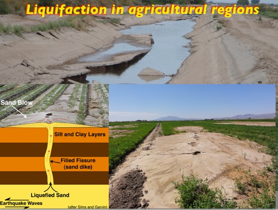
Q: What is liquefaction?
Image set created compiled by Neal Driscoll (Scripps Institution of Oceanography). Photo imagery from the 04 April 2010 magnitude 7.2
Sierra El Major earthquake in Baja Mexico.
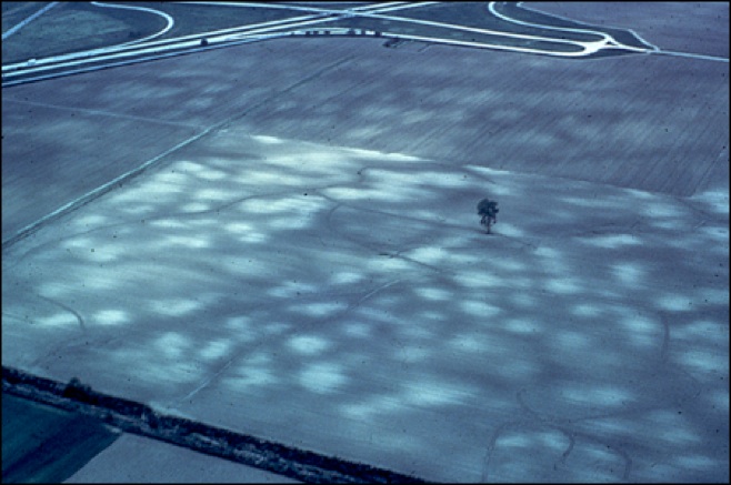
Example of liquefaction. Aerial view of the New Madrid seismic zone. The sand-blows (white dots; diameters of ~40 meters) resulted from a series of 3 very powerful earthquakes (Mw=7.0-7.5) in 1811-1812 (Obermeir, 1996; Hough et al., 2005). For scale, note the Interstate highway interchange in the upper left corner. These vented sand cones are typically 15 to 50 cm in height and the width of a cone is commonly tens of meters (image and information from http://pubs.usgs.gov/of/1998/of98-488/slide14.html).
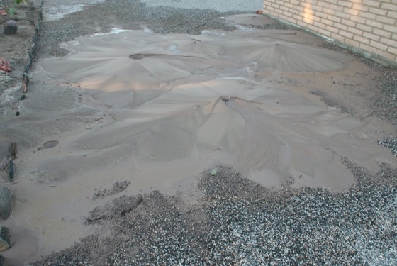
A trip to the beach or a lake shoreline can illustrate the idea of liquefaction: if the sand at the shoreline is wet enough, you will start to sink down, creating a permanent set of footprints embedded in the sand. And a little dance to keep from sinking into what feels like quicksand only causes your dance-floor to become even mushier. Typically the movement will create what looks like water escaping up around your feet and between your toes. What’s happening is the increase in pressure from the body weight causes the water surrounding the grains of sand in the compressed area under your feet to escape into uncompressed regions around the feet. This process whereby the sand becomes mushier, or fluidized, owing to the application of pressure is called liquefaction, and can be caused not only by the amplitude of the stress changes — that is, the body weight in this example — but also by the duration of the stress variations. In a similar way, stress changes induced by the passage of earthquake seismic waves can produce liquefaction in regions of loose grain materials that have a high fluid content.
[Text modified from http://www.nature.com/ngeo/journal/v1/n9/full/ngeo299.html]
Example of liquefaction. Sand blows from the 04 April 2010
Sierra El Major earthquake in Baja California
(photo courtesy of Greg Cox).


Image by Debi Kilb, Scripps Institution of Oceanography
(modified from the work of Karen Luttrell)
