| Model Name | Plot | Hyper Link | Data/Parameterization | Reference | |
| HRV | S362D1 | x | Web Page | x | x |
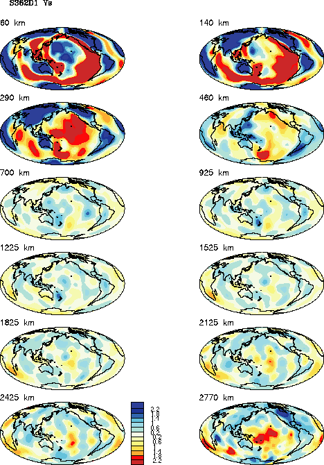
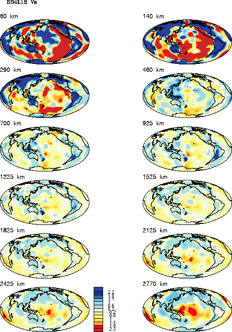
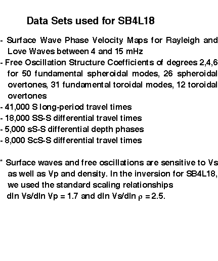
| SIO | SB4L18 | x | Web Page | x | x |
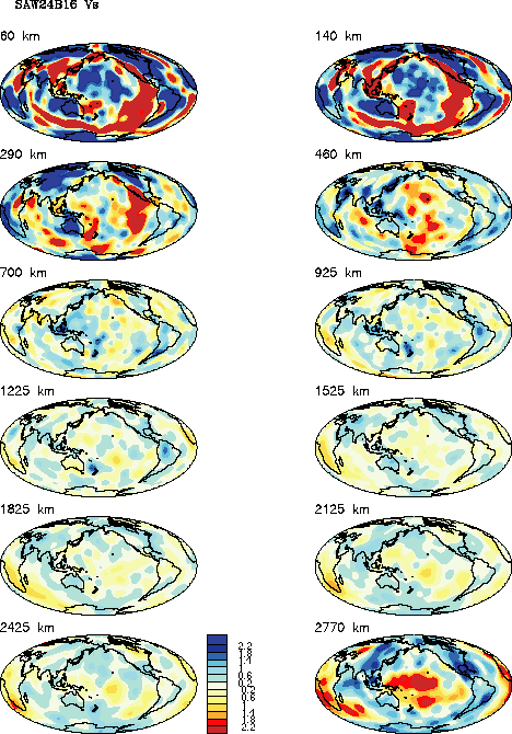
| Berk | SAW24B16 | x | Web Page | x | x |
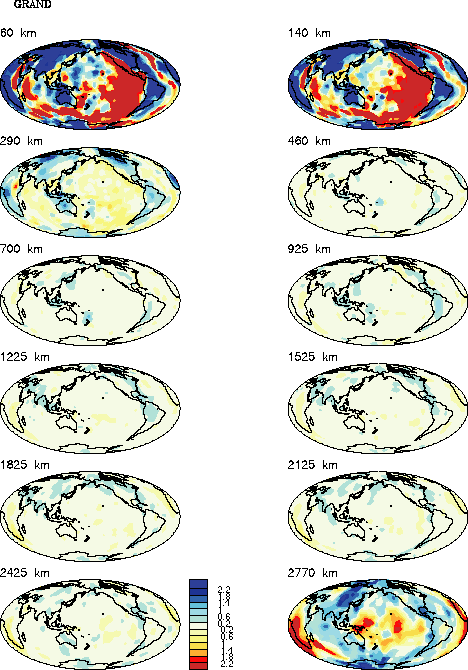
| Grand97 | Grand1 | x | x | x | |
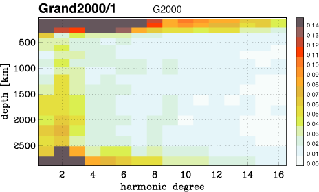
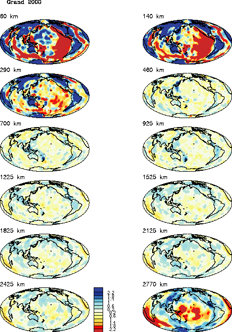
| Grand2000 | G20001 | x | x | x | |
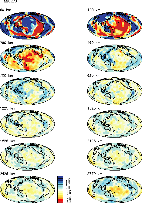
| Calt | S20RTS | x | Web Page | x | x |
| layer index | center depth | upper limit | lower limit | Scripps | Harvard | Berkeley | Caltech | Grand2000 | |
|---|---|---|---|---|---|---|---|---|---|
| 18 | 66.5 | 22 | 111 | x | x | x | x | x | |
| 17 | 155.5 | 111 | 200 | x | x | x | x | x | |
| 16 | 250 | 200 | 300 | x | x | x | x | x | |
| 15 | 350 | 300 | 400 | x | x | x | x | x | |
| 14 | 465 | 400 | 530 | x | x | x | x | x | |
| 13 | 595 | 530 | 660 | x | x | x | x | x | |
| 12 | 735 | 660 | 810 | x | x | x | x | x | |
| 11 | 885 | 810 | 960 | x | x | x | x | x | |
| 10 | 1035 | 960 | 1110 | x | x | x | x | x | |
| 9 | 1210 | 1110 | 1310 | x | x | x | x | x | |
| 8 | 1410 | 1310 | 1510 | x | x | x | x | x | |
| 7 | 1610 | 1510 | 1710 | x | x | x | x | x | |
| 6 | 1810 | 1710 | 1910 | x | x | x | x | x | |
| 5 | 2010 | 1910 | 2110 | x | x | x | x | x | |
| 4 | 2210 | 2110 | 2310 | x | x | x | x | x | |
| 3 | 2410 | 2310 | 2510 | x | x | x | x | x | |
| 2 | 2610 | 2510 | 2710 | x | x | x | x | x | |
| 1 | 2798.35 | 2710 | 2886.70 | x | x | x | x | x | |
| download entire model (tar file) | x | x | x | x | x | ||||
| Depth | Scripps | Harvard | Berkeley | Caltech | Grand2000 | |
|---|---|---|---|---|---|---|
| 350 | x | x | x | x | x | |
| 600 | x | x | x | x | x | |
| 900 | x | x | x | x | x | |
| 1200 | x | x | x | x | x | |
| 1600 | x | x | x | x | x | |
| 2000 | x | x | x | x | x | |
| 2400 | x | x | x | x | x | |
| 2800 | x | x | x | x | x |
| Berkeley model as reference |
| Caltech model as reference |
| Grand 1997 model as reference |
| Harvard model as reference |
| Scripps model as reference |
| Berkeley model |
| Caltech model |
| Grand 2000 model |
| Harvard model |
| Scripps model |
| HRV | SIO | Berk | Grand | Calt | |
| HRV | . | x | x | x | x |
| SIO | x | . | x | x | x |
| Berk | x | x | . | x | x |
| Grand | x | x | x | . | x |
| Calt | x | x | x | x | . |
| Berkeley RCF |
| Caltech RCF |
| Grand 2000 RCF |
| Harvard RCF |
| Scripps RCF |
Goto
REM Home page
Goto
2. REM Workshop Home page