The Beginning of Historical Records
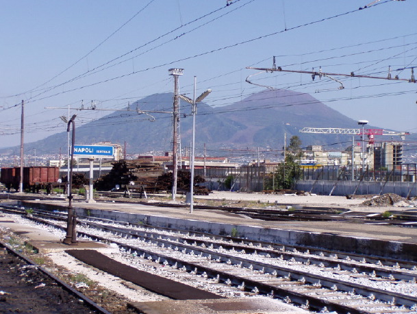
Photo: Gabi Laske
GVP
Wikipedia
Mt. Vesuvius
Location: Subduction Zone, continental arc; stratovolcanoThe catastrophic eruption of A.D. 79 destroyed the cities of Pompeii and Herculaneum and killed at least 2,000 people. Many people probably think of Vesuvius first when they are to name a volcano. The eruption was described in two letters by Pliny the Younger to the Roman historian Tacitus. These are probably the first detailed historic records of a volcanic eruption. Excavations are still going on today. This is particularly difficult at Herculaneum because the current city of Ercolano is built on the ruins of the old city. Until recently it has been believed that all residents of Herculaneum could escape the terrible fate of their neighbors in Pompeii, but recent finds tell a different story. The description of the eruptions of Vesuvius are beyond the scope of this class but for the interested few and for the sake of completeness, there it is. The last know eruption was in 1944.
- Summary of significant eruptions:
- 1139: lava flows, explosive; VEI 3
- 1150: explosive; VEI 3?
- 1631-1632: pyroclastic flows, lahars, tsunami, caldera, explosive; damage; fatalities; VEI 5?
- 1654-1680: lava flows, lahars, explosive; damage; VEI 3
- 1682: lava flows, explosive; fatalities; VEI 3
- 1685-1694: lava flows, explosive; damage; VEI 3
- 1697-1698: lava flows, lahars, explosive; damage; VEI 3
- 1701-1707: lava flows, lahars, explosive; damage; VEI 3
- 1708-1723: lava flows, explosive; damage; VEI 3
- 1724-1730: lava flows, explosive; VEI 3?
- 1732-1737: lava flows, lahars, explosive; damage; fatalities; VEI 3?
- 1744-1761: lava flows, explosive; damage; VEI 3
- 1764-1767: lava flows, explosive; damage; VEI 3
- 1770-1779: lava flows, lahars, explosive; damage; fatalities; evacuation; VEI 3?
- 1783-1794: lava flows, lahars, explosive; damage; fatalities; VEI 3?
- 1796-1822: lava flows, lahars, explosive; damage; fatalities; VEI 3?
- 1824-1834: lava flows, lahars, explosive; damage; VEI 3
- 1835-1839: lava flows, explosive; VEI 3
- 1854-1855: lava flows, explosive; damage; VEI 3
- 1855-1861: lava flows, explosive; damage; evacuation; VEI 3
- 1870-1872: lava flows, explosive; damage; fatalities; VEI 3
- 1875-1906: lava flows, pyroclastic flows, lahars, explosive; damage; evacuation; fatalities; VEI 4?
- 1913-1944: lava flows, pyroclastic flows, explosive; damage; evacuation; fatalities; VEI 3
Hotspots
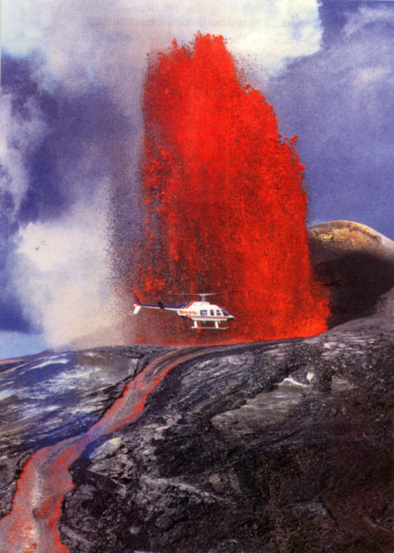
Photo: Douglas Peebles,
from "Earth" by Tarbuck&Lutgens
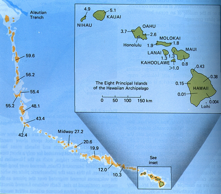
Hawaii
Location: hotspot; shield volcanoThe other half of people probably think of Hawaii when they are to name a volcano. Hawaii is the archetype hotspot volcano sitting in the middle of the Pacific plate, far away from any plate boundary. Scientists looked at the Hawaiian islands when the theory of island chains forming on plates that move over fixed mantle plumes was developed. The bend has been thought to indicate a change in plate motion direction (though recent research leaves this question somewhat open). The theory of mantle plumes has been questioned in recent years as seismologists struggle to image them. The bend has also caused some headache as geologists struggle to find a cause for the "sudden" change in plate motion and bends in different island chains on the Pacific plate don't seem to match. Cracks in the plates have been suggested as alternative causes. As this is subject to ongoing debate, let's assume for this class that the plume theory still holds.
The Hawaiian volcanoes are major tourist magnets and Kilauea is currently erupting "peacefully". The still ongoing activity started in 1983 with spectacular lava fountains at Pu'u O'o, one of its vents. Right now lava oozes out into the sea and is the only activity to watch but it's still amazing. Significant activity is actually going on at the ocean floor to the southwest where Loihi is growing to be the youngest of Hawaii's volcanoes. It's top is less than 1km below the sea surface.
Fissure Eruption
Photo: Smithsonian Institution
Grimsvötn at GVP
Wikipedia
Laki Fissure, Iceland
Location: Hotspot interacting with mid-ocean ridge; fissure/shield volcanoGrimsvötn is Iceland's most frequently active volcano and lies under the large Vatnajökull ice cap. Grimsvötn has long fissures extending from the center. One of them is the Laki fissure that produced the largest known historical lava flow during a 7-month long eruption in 1783. This eruption was documented by Benjamin Franklin. Lava flows easily in such fissure eruptions that can be 25 km long. When significant amounts of water are involved, lava fountain activity forms "curtains of fire".
- the 1783 eruption was preceeded by a week of earthquake activity
- June 8, 1783: 25km (15.5mi) long fissure opens, basaltic lava gushes out for 50 days at 5000 m3/s) (for comparison, the mightiest North American river, the Mississippi River, empties into the Gulf of Mexico at just 3 times this rate)
- the total volume of produced lava is estimated to be 15km3 (3.6 cubic miles)
- release of enormous volume of SO2-rich gases with an unusually large amounts of flourine that enshrouded Iceland and Northern Europe in a blue haze ("dry fog")
- gases slow the grass growth and increase its flourine concentration which kills 75% of the horses and sheep ad 50% of the cattle
- the 7-month eruption causes extensive crop failure in Iceland
- famine that kills 10,000 people reducing Iceland's population by 20%
- Summary of significant eruptions:
- 1783: subglacial eruption; explosive; lava flows; damage; fatalities; evacuation; VEI 4+
- 1873: subglacial eruption; explosive; VEI 4
- 1902: subglacial eruption; explosive; VEI 4
- 1996: subglacial and crater lake eruption; explosive; lava flows; damage VEI 3?
- 1998: subglacial and crater lake eruption; explosive; VEI 3
- 2004: subglacial and crater lake eruption; explosive; VEI 3
Famine, Global Cimate Change
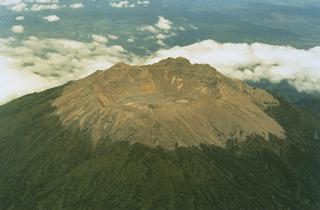
Photo: Smithsonian Institution
GVP
Wikipedia
Tambora, Bali/Indonesia
Location: Subduction Zone, island arc; stratovolcanoTambora is known for the most violent eruption of the last 200 years that eventually killed 117,000 people. Only 10% of these where killed by massive pyroclastic flows while 90% were actually killed by indirect means: famine induced by global climate change. The eruption triggered brilliant sunsets and reduced temperatures in Western Europe, northeastern America and Canada. 1816, known as "the year without summer", brought typhus throughout Europe, famine in Switzerland and crop failure in New England.
- the eruption in April 1815 was preceeded by moderate activity
- April 5: Plinian column with 12km3 of Pumice shoots up 33km (20mi) high for 2h
- April 10: even more powerful Plinian erutpion blasts 44km (27mi) high for 3h; vent is opened through explosion
- April 11: exposed lava body pours out of crater (50km3) in overwhelming pyroclastic flow
- the pyroclastic flow reaches Sumbawa and kills 10,000 people
- week-long activity produces ca. 150 km3 of volcanic material
- the 4,000m (13100ft) tall volcano is reduced to 2650m (8700ft), with a 6km wide and 1km deep caldera
- the associated explosions are audible up to 2600km (1600mi) away
- volcanic ash falls as far as 1300km (800mi) away
- the total volumes of ejected debris is estimated to be between 80 and 160km3
- cultural significance: this eruption destroys the feudal kingdoms of Sanggar and Tambora and erases the Tamboran language
- last known eruption:1967
- Summary of significant eruptions:
- 1812-1815: largest historical eruption worldwide (see above); VEI 7
- 1819: explosive; VEI 2
- ca. 1880: lava flows; explosive; VEI 2
- 1967: lava flows; VEI 0
Destructive Lava Flows
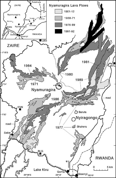
Nyiragongo/Nyamuragira, Dem.Rep.Congo
Location: Continental Rift; shield volcano (Nyamuragira); stratovolcano (Nyiragongo)Nyiragongo and Nyamuragira are some of the (few) effusive volcanoes that usually are not big killers but cause substantial property damage through lava flows (rather than explosive volcanism). Nyiragongo is a strato volcano and has a long-lived lava lake that repeatedly releases extensive extremely fluid lava flows (e.g. 1977); the last one destroyed parts of the city of Goma. Nyamuragira is a shield volcano and is Africa's most active volcano. It also has a lava lake that is active since at least 1921. Its lava flows can travel more than 30km and reach lake Kivu.
- January 17, 2002; lava flows rapidly down the slopes of Nyiragongo, killing 45 people
- lava flows toward Lake Kivu to destroy 25% of the city of Goma
- lava stream basically divides the city, just barely missing the airport
- possible precaution: slowing down of lava flow by spr of water (e.g. Iceland, Mt. Etna) and building barricades though this has only moderate success rates
Pyroclastic Flows
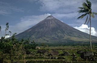
Photo: Kurt Fredrickson, 1968,
Smithsonian Institution
GVP
Wikipedia
Mt. Mayon, E. Luzon/Philippines
Location: Subduction Zone, island arc; stratovolcanoMt. Mayon is Philippines most active volcano and has had 48 recorded eruptions since 1616. At least nine of these have caused fatalities in the densely populated area, the deadliest eruption being in 1814 which cost between 1500 lives (GVP) and 2200 lives (wikipedia). An eruption in 1993 killed 75 farmers in a ravine that had been off-limits. 50,000 residents were evacuated in anticipation of a possible larger eruption. Many residents had to be forcibly removed but returned during the day to tend their fields (the crops are their only income). The last eruption was in 2009.
- 1814: pyroclastic flows and lahars kill at least 1500 people; VEI 4
- 1853: pyroclastic flows, lahars with fatalities; VEI 3
- 1858: lava flows, pyroclastic flows, lahars with fatalities; VEI 2
- 1871: pyroclastic flows, lahars with fatalities; VEI 3
- 1881: lava flows, pyroclastic flows, lahars; VEI 3
- 1886: lava flows, pyroclastic flows, lahars with fatalities; VEI 3
- 1897: pyroclastic flows, lahars with fatalities; VEI 4?
- 1828: lava flows, pyroclastic flows, lahars with fatalities; VEI 3
- 1838: pyroclastic flows, lahars with fatalities; VEI 2
- 1848: evacuation; pyroclastic flows, lahars with fatalities; VEI 2
- 1968: evacuation; an eruption sends an ash could 10km (6mi) high;
- the collapse of the cloud sends a pyroclastic flow down the mountain slope at speeds of 50-100km/h (30-60mph); lava flows; fatalities; VEI 3
- 1984: 73,000 evacuated prior to eruption; no casualties; VEI 3
- 1993: evacuation; pyroclastic flows, lahars, fatalities; VEI 2?
- 1999: evacuation; pyroclastic flows, lahars, lava flows; VEI 3
- 2001: evacuation; pyroclastic flows, lava flows; VEI 3
- 2006: evacuation; pyroclastic flows, lahars, lava flows; fatalities; VEI 1!
- 2009: evacuation; pyroclastic flows, lava flows; VEI 2
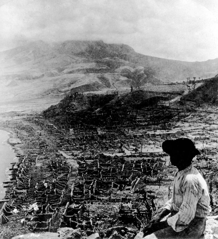
Photo: Underwood and Underwood, Library of Congress
Mt. Pelee, Martinique
Location: Subduction Zone, island arc; stratovolcanoThe eruption in 1902 was the deadliest volcanic eruption in the 20th century when directed blast formed a massive pyroclastic flow. This is a particularly sad case as many residents were kept from evacuating because of political reasons. Mt. Pelee had erupted before in 1792 and 1851, and then later in 1929-1932 when hot ash and gases overspilled the crater forming numerous pyroclastic flows.
- early spring 1902: activity begins; crater fills with extremely viscous magma plugging it; occasional explosions free up the crater
- late April: 700 people/day start to flee the countryside and move through St. Pierre, 10km from the volcano
- May 5, noon:a large pyroclastic flow moving south destroys a sugar mill and kills 40 people
- governor stops a mass exodus because of upcoming elections on May 10
- May 8, morning: a directed blast of gas-charged lava creates an incandescent pyroclastic flow (nuee ardente) with internal temperatures of more than 700oC (1300oF)
- pyroclastic flow speeds through St. Pierre in the south at 190km/h (310mph) killing 29,000 people including sailors in boats at sea, except for two people including one prisoner in his cell
- May 20: another nuee ardente
- August 30: nuee ardente flows east killing 2,000 people
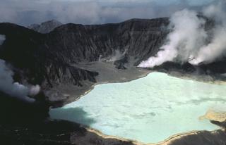
Photo: Bill Rose, 1983 (Michigan Technology University)
from: Smithsonian Institution
El Chichon, Mexico
Location: Subduction Zone, continental arc; lava domesEl Chichon's main feature is an emerging lava dome. Chichon had been dormant for 550 years when in 1982 it produced the deadliest pyroclastic flow in modern times (since 1955).
- March 1982: activity starts with numerous earthquakes
- March 29: unexpected 6h-long Plinian eruption; 1.4km3 (0.35 cubic miles) of material; rural farmers stayed
- only minor eruptions for the next 5 days, lulling residents into false safety
- April 4: a ring-shaped pyroclastic base surge travels 8km (5mi) outward, overrunning 9 villages and killing 1700 people
- a Plinian eruption follows (20km high column) with more base surges
- the Plinian column injects enough SO2 into the upper atmosphere to temporarily affect the global climate
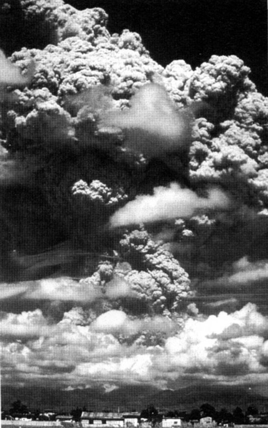
Mt. Pinatubo, Luzon/Philippines
Location: Subduction Zone, island arc; stratovolcanoThe 1991 eruption of Mt. Pinatubo was the largest volcanic eruption in the 20th century. It injected so much material into the atmosphere that it lowered the global temperature temporarily counteracting the warming greenhouse effect. Seismic monitoring that began only months prior to the eruption and resulting precautionary measures were a great success story. One million people (incl. 20,000 U.S. military personnel) that lived in the danger zone were evacuated so that the number of fatalities could be limited (about 1,000). Most of these were killed in the huge pyroclastic flow. According to the course book 300 people died (the published number is actually 3-4 times higher). It is estimated that 20,000 might have died and $500 Mio of property destroyed (especially military equipment) without forceful warnings. The monitoring expenses are estimated at $1.5 Mio.
- March: seismic activity indicates Mt. Pinatubo awakens from 500-year long slumber; magma moves upwards from 32km depth; thousands of small earthquakes; 2 small steam blasts; emission of thousands of tons of SO2-rich gases; intense seismic monitoring begins
- June 7: magma reaches surface and is oozing out after having lost most of its dissolved gases
- June 12: large explosion due to millions of cubic meters of gas-rich magma reaching the surface
- expedited evacuation of all residents
- June 15: cataclismic eruption; > 1km3 (0.25 cubic miles) is thrust 35km (22mi) up into the atmosphere in an ash cloud 480km (300mi) across; pyroclastic flows fill valleys 200m (660ft) deep; an incoming typhoon washes unconsolidated ash down the slopes in lahars.
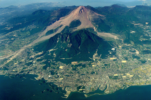
Photo: 1995, Nagasaki Photo Service
Mt. Unzen, Japan
Location: Subduction Zone, very old island arc; complex volcanoMt. Unzen has a growing lava dome. A steady magma supply causes the dome to become unstable. Junks of viscous lava break off in explosive eruptions and pyroclastic flows speed down the slopes. There have been more than 7000 flows between 1991 and 1994. Cities line the coast near the volcano and farming villages thrive on its lower slopes posing a significant hazard risk to the area.
- May 21 1792: an earthquake triggers the collapse of the lava dome and sends a large debris avalanche (0.3km3) down the slope
- avalanche travels for 6.5km (4mi) before reaching the sea and creating a tsunami that kills 15,000 people
- May 1991: growth spurt of lava dome towring above the crater rim
- thousands of residents are evacuated, while scientists and journalists stay
- a 100m (325ft) high mass collapses causing a pyroclastic flow
- June 3, 4:09pm: a huge pyroclastic flow rolls downslope at 95km/h (60mph) killing 43 observers, including volcanologists Maurice and Katya Krafft.
Lahars (Mudflows)
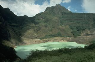
Photo: Dan Dzurisin, 1980; USGS;
from: Smithsonian Institution
Kelut, Java/Indonesia
Location: Subduction Zone, island arc; stratovolcanoKelut is a volcano Indonesia in the tropical climate belt. After an eruption, new pyroclastic material decomposes quickly to form fertile soil. This attracts many people to live near the volcano despite the threat of imminent eruptions. A large summit crater lake (water, not lava) often empies out during eruptions (15 times in the last 200 years). A debris flow formed during an eruption in 1586 killed 10,000 people making this eruption the 7th deadliest within the last 500 years.
- 1919: a surprise eruption forces 40 Mio m3 of lake water down the slopes of loose pyroclastic material forming 3 major lahars travelling at 65km/h (40mph)
- more than 5,000 people are killed
- in the aftermath and to prevent future such disasters, Dutch engineers dig tunnels to reduce the lake size by 95%; however a later eruption in 1966 dumps 20 Mio m3 water killing 282 people. A new deeper tunnel proves effective for hazard reduction during an equally violent eruption (VEI=4) in 1990 in which none or very few people perish.
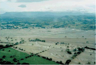
Photo: J. Marso; USGS;
from: "Earth" by S. Marshak
Nevado del Ruiz, Colombia
Location: Subduction Zone, continental arc; stratovolcanoNevado del Ruiz stands 5,400m (17700ft) tall and has a 10-30m (30-100ft) thick ice cap at its top. During relatively small eruptions the ice cap melts sending lahars down the mountain slopes. Some valleys get repeatedly devasted by lahars. Armero that was destroyed in 1985 was devasted before in 1845 when 1,000 people lost their lives.
- Nov 1984: vlocano awakens with small-scale activity
- Nov 10, 1985: continuous harmonic tremors foretell a large eruption
- 9:37pm: a Plinian eruption column rises several km high; pyroclastic material causes the ice cap to melt sending a lahar down the slopes only 20 min later, killing 1800 people
- increased activity melts more ice
- 11:00pm: a massive lahar travelling 45km (30mi) at 45mk/h (30mph) reaches Armero burying 22,000 of its 27,000 residents under a 8m (26ft) thick blanket of mud
Calderas
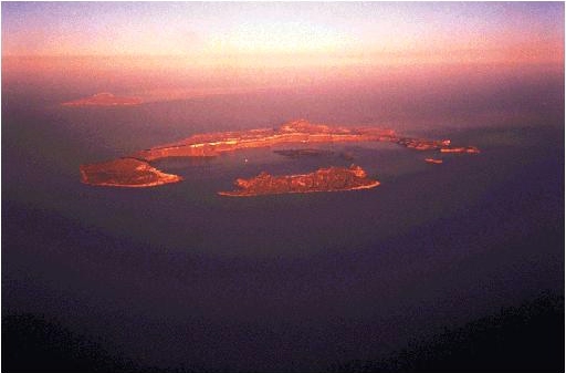
Santorini, Greece
Location: Subduction Zone, island arc; shield volcano/calderaSantorini is a ring-shaped group of small islands that once formed a large volcano behind the subduction arc of the Aegean Sea. The island hosted the city of Akrotiri that was only recently discovered (Greek archeologist Spyridon Marinatos started excavation in 1967). Akrotiri was an important city of the Minoan culture in the Bronze Age about 3700 years ago. It had 3-story buildings, paved streets, a sewer system, and beautiful wall frescoes. A cataclysmic eruption about B.C. 1650 destroyed the main volcano, leaving behind a caldera. Santorini is one of the possible sites of the ledendary Atlantis described by the Greek philosopher Plato (B.C. 427 - 347). It is believe that this eruption (together with its consequences) was one of the main causes for the fall of the Minoan civilization.
- A large earthquake destroyed parts of the city of Akrotiri (excavation revealed broken stairs!)
- earthquake may have alarmed residents to flee by boat (no skeletons have been found on the island!)
- a sequence of eruptions ended with the production of massive amounts of white pumice that now cover the rim of the islands up to 70m (230ft) high; volcano produced a total of 30 km3 (7 cubic miles) of material
- ash found more than 30cm (1ft) high in Turkey, over 300km (200mi) away
- a cataclysmic eruption leads to the collapse of the volcano leaving behind a 10km (6 mi) wide caldera
- floor of caldera is now 400m (1300ft) below sea level
- the caldera collapse triggered a huge tsunami that was still 70m (230ft) high on the island of Crete, 170km (105mi) away (pumice found in the hills!)
- quarrying the pumice is now Santorini's second-larges income, after tourism
- island can sustain only a limited population as is has no ground water
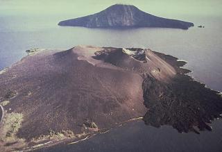
Photo: Volcanological Survey of Indonesia, 1979;
from Smithsonian Institution
Krakatau (also Krakatoa; mispelled?), Java-Sumatra/Indonesia
Location: Subduction Zone, island arc; calderaKrakatau started erupting after two centuries of quiescence. The eruption in 1883 was the second-deadliest eruption in historic times, second only to the Tambora eruption in 1815. Only 10% of the fatalities were due to the volcanic eruption itself while 90% were kill in the tsunami.
- the eruption sequence beins with a small eruption on May 20, 1883
- August 26, 2pm: large blast shoots volcanic ashes and pumice 28km (17mi) high (Plinian eruption); one of the cones collapses into the sea creating a tsunami
- August 27, 10am: stupendous blast shoots ashes and pumice 80km (50mi) high; the blast is distinctly heard 5000km (3100mi) away
- a hot gaseous pyroclastic flow is sent on the water across the Sunda Straight toward Sumatra , 40km (25mi) away; flows on-shore and kills 2000 people
- the collapse of the volcano forms a caldera causing a 35m (115ft) high tsunami; the tsunami travels around the world and is recorded in Portugal/Europe
- 295 towns are destroyed; 36,000 people killed
- the eruption sequenced produced 18km3 (4.3 cubic miles) of material
- the island which was once 450m (1475ft) high is destroyed and the caldera floor is 257m (850ft) below sea level
- 1927: a new volcano forms an island in the center of the caldera (Anak Krakatau = "child of Krakatau")
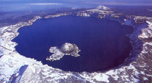
Photo: Greg Vaughn/Tom Stack&Assoc.
from: "Blue Planet" by Skinner&Porter
Crater Lake/Mt. Mazama, Oregon
Location: Subduction Zone, continental arc; calderaCrater Lake (which is actually a caldera!) was formed during a large eruption of Mt. Mazama, about B.C. 5677; the caldera is 9.5km (6mi) across and 589m (1925ft) deep: Mt. Mazama once stood 3660m (12,000ft) high, while the highest point of the rim now is at 2720m (8925ft)
- a major Plinian eruption and ejection of immense volume of material leads to collapse forming a caldera;
- ash fall extends from Long Valley Caldera/California well into Canada
- traces of ash found in Greenland glacier ice layer which pins down exact timing of eruption
Massive Gas Emission
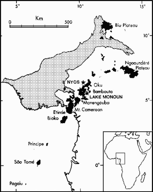
Lake Nyos and Lake Monoun, Cameroon, Africa
Location: hotspot track/failed triple junction rift; maarThese are no volcanoes in the classic sense, but there is "volcanic activity" in the form of repeated emission of large quantity of volcanic gases (mainly CO2) that kill a lot of people. The lakes are located along the Cameroon volcanic line in a failed rift of the triple junction that formed during the separation of Africa and South America. The "crater lakes" are not at the top of volcanic mountains but are so-called maars that have been formed during violent gaseous explosions.
- 9:30pm on August 21, 1986: loud noise rumbles through the Lake Nyos area; gigantic volume of gas (1 km3) belches from the lake and sweeps 25km (16mi) down the valley
- the gas mass has a high CO2 content which is heavier than air; 50m (164ft) thick, travelling at 72km/h (45mph)
- 1700 people and 3000 cattle are asphyxiated; only few survive, awakening from coma after several hours; plants are unaffected
- gas probably comes from underlying basaltic pluton; gas can accumulate at the bottom of the lake beneath the water until its pressure reaches the hydrostatic pressure and the stratification becomes unstable
- trigger of belch: unknown; could be due to: volcanic eruption; landslide; earthquake; wind disturbance; change in internal temperature;
- a similar release of CO2 in Lake Monoun on August 15, 1984 was triggered by an earthquake and associated landslide
- possible prevention: pumping out of CO2 so that critical concentrations cannot form
New Land
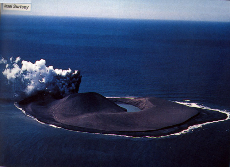
Photo: IFA-Bilderdienst, Ottobrunn
from: Taschenatlas "Erdbeben und Vulkane" by Haack
Heimaey/Surtsey, Iceland and Paricutin, Mexico
Location: Surtsey- hotspot interacting with mid-ocean ridge; submarine volcano; Paricutin - subduction zone, continental arc; cinder coneSome volcanic eruptions create new land and new volcanoes.
The mostly submarine Vestmannaeyjar volcanic system consists of a group of volcanic islands and submarine cones occupying a shallow shelf off the south coast of Iceland. Eldfell, the volcano on the island of Heimaey had not erupted for 5000. On January 23, 1973 a fissure open up only 1 km from the town of Vestmannaeyjar on Heimaey. Early lava flows destroyed about 300 buildings and filled in the harbor. The residents bulldozed pyroclastic material into barriers to divert the lava flows. They sprayed seawater on the flows to stop them from advancing. By July 1973, 230 Mio m3 of lava and 26 Mio m3 of pyroclastic material increased the island by 20%.
Volcanic activity can create new islands and new volcanoes. Volcanic activity had been submarine when in November 1963 huge steam explosions initiated the birth of the island of Surtsey. The steam pressure ejected ash 5 km into the atmosphere and Surtsey finally emerged on November 14, 1963 in a phreatic eruption, building a cone of ash and lapilli that rose almost 200m above sea level in just 3 months.
Similar eruptions can happen on land as well. On February 20, 1943, a new volcano formed when eruptions blasted through fields near the village of Paricutin/Mexico. The volcano erupted for 9 years forming a distinctive cinder or scoria cone. Lava flows eventually buried 260 km2 (100 square miles) of land, destroying the cities of Paricutin and San Juan de Parangaricutiro.
Dormant in Pacific NW?
Lassen Peak, California
Location: subduction zone, continental arc; stratovolcanoLassen Peak is currently not active and is also not a typical volcano. Nevertheless it is not extinct and is a serious natural hazard. The towns of Viola and Drakesbad are about (16km) 10mi from the Peak. The magma at Lassen is very viscous and creates large lava domes that eventually become unstable and potentially cause deadly pyroclastic flows. In 1914-17 and unusually large lava dome formed within the ruins of Mt. Tehama, an older grand volcano.
- May 1914: Lassen awakens with major eruption following on July 18
- 3350m (11,000ft) high ash cloud
- May 19, 1915: viscous lava flows west downhill and a massive lahar (melt water from snow cap) flows 50km out to the east; on the north slope a pyroclastic flow devastates forest as far as 6.5km (4mi)
Mt. Shasta, California
Location: subduction zone, continental arc; stratovolcanoMt. Shasta (4318m; 14,162ft) is the second tallest of the Cascade Range volcanoes. Shasta stands 3000m (9800ft) above the surrounding area and is visible from 160km (100mi) away. It is currently not active but has erupted 11 times in the last 3400 years and at least 3 times in the last 750 years; its last eruption probably was in 1786; there is a substantial hazard risk from lahar flows in valleys of growing towns; in fact, 3 towns stand on debris flows that are 8 times larger than those of Mt. St. Helens.
Mt. Rainier, Washington
Location: subduction zone, continental arc; stratovolcanoMt. Rainier (4393m; 14,413ft) is the tallest of the Cascade Range volcanoes. Its summit is 68 km(42 mi) from the center of Tacoma, a city of 200,000 people; it is 94 km (58 mi) from Seattle, a city of 615,000 people. The greater metro area is home to 3.4 Mio people. Rainier stands 2300m (7500ft) above the surrounding area. It has a glacial cap which potentially makes it as dangerous as Nevado del Ruiz whose lahar killed 25,000 people in its 1985 eruption. Rainier produced numerous far-reaching lahars in the past; the Osceola mudflow about 5,600 years ago travelled 120km (75mi) affecting an area that is now home to 100,000 people. The Electron mudflow that traveled 48km (18mi) is only 500 years old. The most recent eruption may have taken place in 1894.
- current activity limited to
- high level of seismicity
- extensive hot springs system
- has erupted in historic times
Mt. Hood, Oregon
Location: subduction zone, continental arc; stratovolcanoMt. Hood (3426m; 11,240ft) is Oregon's highest peak. Its summit is 75 km(46 mi) from the center of Portland, with 580,000 people the largest city in Oregon. Mt. Hood erupted in historic times (last known eruption 1866) and produced debris avalanches and lahars that traveled down the north slope and crossed the Columbia River 40 km (25 mi) away. Mt. Hood had at least 4 major eruptions in the last 15,000 years. The last 3 occurred within the past 1800 years. Minor 19th-century eruptions could be observed from Portland.
Mt. St. Helens, Washington
Location: subduction zone, continental arc; stratovolcanoMt. St. Helens (current summit at 2549m; 8,363ft; before 1980 eruption: 2950 m/9,677 ft) is the most active of the Cascade volcanoes. Prior to the 1980 eruption, St. Helens, sometimes called the Fuji-san of America before 1980, can be dormant for 1000s of years. Prior to 1980, the last eruption was in 1857. Activity on the volcano started with a magnitude 4.1 earthquake on 20 March 1980 after which time the volcano was monitored. Seismicity ceased, prompting officials to remove previously installed road blocks. Scientists continue to monitor the volcano with geodetic instruments (tilt meters and theodolites) and noticed the growth of a bulge on the northern flank by mid-april. By 10 May, scientists and officials were concerned enough that road blocks were re-installed and only residents were allowed into the evacuation area to retrieve their belongings. A complex magnitude 5.1 earthquake on 18 May 1980 triggered a landslide, allowing the instant release of pressure building up in the volcano, and the catastrophic explosion. The eruption was more violent than expected and killed 57 people despite evacuation efforts. Four of these people were within the restricted zone including a scientist who was supposed to observe and document the eruption, two amateur volcanologists and an old resident who had special permission to stay at his lodge at Spirit Lake. St. Helens blew its top in a VEI-6 eruption. Ash was transported east and fell as far away as Montana. Apart from a small lava flow, St. Helens produced extensive pyroclastic flows (caused by a directed blast), and lahars ultimately clogged the Columbia River.