A Global Digital map of
Sediment Thickness
Gabi Laske and Guy Masters
UPDATE (April 24, 25): On 5/12/25, NOAA will decommission links to important datasets on their NCEI website that are relevant to CRUST1.0 as well as our sediment thickness map. Find an alternate link for the ocean crustal age database (Dietmar Mü crustal age) at https://www.earthbyte.org/age-spreading-rates-and-spreading-asymmetry-of-the-worlds-ocean-crust.
Find an alternate link for the ocean sediment digital database at https://data.caltech.edu/records/k4070-ngc79
LAST UPDATE (September 06, 10): The anonymous ftp site for the model
has moved. This did not affect the tar file containing all files. The links to individual
files have been reopened.
IMPORTANT NOTICE (June 23,99): If you have used the whole model
(thickness+elastic parameters) using the tar file that was created before June 99, please
replace it with the current model. The old model had a bug that caused the
shear velocity in the first layer to be too small (sometimes negative) in very thin
sediments (<100m) in some oceanic areas. This affected about 30 of the 64800 1x1 deg cells.
We greatly appologize for any inconvenience.
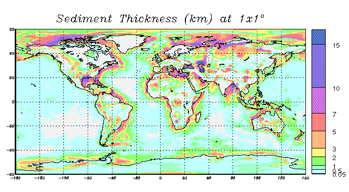
Sediment Thickness
This global sediment map is digitized on a 1x1° scale. In the
oceans, published digital high-resolution maps were averaged (e.g.
Pacific, Indian and South Atlantic oceans).
In areas for which such files are not available (e.g. Arctic and
North Atlantic ocean), the sediment thickness was hand-digitized
using atlases and maps. The sediment thickness in most of the
continental areas (incl. shelves) were obtained by digitizing the
Tectonic Map of the World provided by the EXXON production research
group (1985).
This map (incl. the postscript file) is available as part of a
package including the whole 3-layer sediment model. Go to download section for details.
top
Why is this map important?
Many of the global seismic long-period data used in
mantle tomography are sensitive to variations in crustal
structure but are not able to resolve it. For example, the
contribution of the crust to global phase velocity maps of 150s
Rayleigh waves is about half of the total signal (and is of opposite
sign of that of the underlying mantle). Most authors handle this by
applying a "crustal correction" to the data before an inversion
for mantle structure. Since the inversion techniques can erroneously
map crustal structure down to great depth, accurate crustal
corrections to the data sets are extremely important. A significant
contribution comes from thick sedimentary basins which have rather
low values of seismic velocities and density.
Hence, accurate knowledge of the structure of the
"sedimentary layer" in a crustal
model is crucial.
top
Elastic Properties
Sediments have rather low seismic velocities and densities. In order
to evaluate the seismic and gravity signal of large sedimentary
basins, in situ information of these parameters become important.
Seismic velocities (Vp and Vs) and density are specified on the same
1x1° grid and are also available with the map.
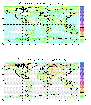 |
Since the seismic velocity changes
rather rapidly with depth, it is necessary to subdivide the
sedimentary cover. We chose to specify the elastic parameters in a
3-layer model.
While the top layer covers the first 2km of sediments,
the second one (both shown here) covers the 5km underneath. For
areas with sediments thicknesses larger than 7km, a third layer
covers the rest (not shown here).
|
 |
For much of the oceanic areas, detailed information of P-velocities
are available in form of regional velocity functions (v=v0
+Kt, where t is one-way vertical travel time to layer mid-points).
The plot shown here summarizes areas where velocity functions are
available
(areas of the same color do NOT have the same
velocity function).
The velocity functions will be summarized in a future
publication and are available upon request
(
gmasters@ucsd.edu).
|
 |
On continents, the velocities are less well
known, as most refraction seismic profiles do not yield detailed
information on the sedimentary cover. We therefore adopt the values
given in CRUST 5.1 (2.1-2.5km/s in the first 2km, then 3.2-5.3km/s).
The plot shown here summarizes Vp in the first two layers.
Details on CRUST 5.1 can be found in the next section.
|
Since in situ information on shear velocity and density are not yet
available on global scale, we use the curves of Ludwig, Nafe and
Drake to obtain these values.
top
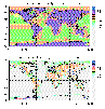
A comparison with CRUST 5.1
CRUST 5.1
( Mooney et al., 1998) is a global crustal
model, specified on a 5x5° grid. This model specifies
compressional and shear velocity as well as density in seven
layers (ice; water; soft and hard sediments; upper, middle and lower
crust).
This model has been completed
before the new 1x1° sediment model was available.
 |
We average the new sediment map to 5x5°
cells and compare the resulting map to the sedimentary cover
of CRUST5.1 (layers 3 and 4, soft and hard sediments).
|
 |
There is general agreement between the two maps and CRUST5.1
represents the actual thickness in most of the oceanic areas. Significant
differences (up to 2.9km) can be found in some shelf
regions and sedimentary basins
(e.g. Arctic, north of Greenland). Sediments on
continents appear slightly overpredicted by CRUST5.1, especially
in Eurasia and the
Western U.S..
|
 |
The Arctic and
Antarctic Regions.
|
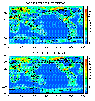
Due to low values of seismic velocities and density, even small
errors in the representation of the sedimentary cover can lead to
significant changes in the seismic signal (e.g. for surface wave
dispersion).
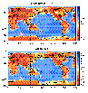 |
To illustrate this, we calculate phase velocity maps for Rayleigh
wave at 35 seconds (28mHz) using our new sediment map and our
global crustal model CRUST 5.1. In the top map, the sediments
of CRUST 5.1 have been replaced with the new model, while the lower
panel shows the predictions of CRUST 5.1 (with the CRUST 5.1
sediments).
|
 |
In the difference plot, many blue areas correlate with
red areas in the sediment difference map (e.g. Artic Ocean north of
Greenland). A lack of sediments in CRUST 5.1 yields
high phase velocities that are too high. Overestimation of the sediment
thickness in large parts on the continents in CRUST 5.1 (e.g.
Eurasia) leads to velocities which are too low.
|
top
Related Sites
Note: see also
NGDC web site.
The thickness map shown here basically uses the same maps as the NGDC
map in the Indian, South
Atlantic and Pacific oceans (with a few exceptions).
top
Publications
A manuscript describing the model in detail is in preparation. Please
refer to the following publication when you use our model:
G. Laske and G. Masters, A Global Digital Map of Sediment Thickness,
EOS Trans. AGU, 78, F483, 1997.
top
References
Ludwig, W.F., J.E. Nafe and C.L. Drake, Seismic Refraction, in "The
Sea, Vol. 4, Ideas and Observations on Progress in the Study of the
Seas", A.E. Maxwell (ed.), Wiley-Interscience, New York, 1970.
Mooney, W.D., G. Laske and G. Masters, CRUST5.1: A global crustal
model at 5°x5°. J. Geophys. Res., 103, 727-747, 1998.
Sediment Maps used in this study
| Reference | Region Covered |
| Tucholke, 1986 | North Atlantic (DNAG) |
| Tucholke and Uchupi, 1989a | North Atlantic (atlas) |
| Tucholke and Uchupi, 1989b | Mid Atlantic (atlas) |
| Divins and Rabinowitz, 1989 | South Atlantic |
| Salvador, 1986 | Gulf of Mexico (DNAG) |
| Jackson and Oakey, 1986 | Arctic Ocean (DNAG) |
| Hayes, 1991 | Antarctica, Southern Oceans |
| Ludwig and Houtz, 1979 | North and South Pacific Ocean |
| Renkin and Sclater, 1988 | North Pacific Ocean |
| Rabinowitz et al., 1988 | Indian Ocean |
| Exxon, 1985 | global sediment map (here, Continents) |
| Beloussov and Pavlenkova, 1984 | Eurasia |
top
Acknowledgments
We would like to thank Jean-Yves Royer, Lisa Gahagen and John Sclater
for providing us with digital versions of maps of the Indian and
Southern Oceans, as well as the Pacific and South Atlantic
Oceans.
We are also grateful to
Robert Houtz who provided velocity functions and pointers to the
literature.
top
Download section
Click here to get a README and download the sediment map and files of the whole
3-layer sediment model. Please check the README file for instructions.
To download a compressed tar file with everything included (use gzip to uncompress)
Click here.
As we are interested in
feedback, please let us know for what you use the model and/or
which area could be improved.
top
Gabi Laske (
glaske@ucsd.edu)
Goto
Gabi's Home page
 To IGPP Home


