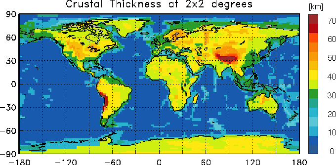
CRUST 2.0
A New Global Crustal Model at 2x2
Degrees
Gabi Laske, Guy
Masters and Christine Reif
UPDATE (July 15, 13): CRUST1.0 is now released. Please go to the CRUST1.0 webpage. We no longer update CRUST2.0 and related services. The page remains open but we discourage usage of this model.
UPDATE (April 13, 12): We are currently modifying our CRUST1.0
proto-type model after testing revealed some inconsistencies with recent surface wave data.
We are modifying the model and expect release by August 2012
UPDATE (March 17, 11): Global average, average continental
profile and average oceanic profile are given below.
UPDATE (March 09, 11): Google Earth kmz file available
for crustal thickness. Go down to download section.
UPDATE (September 06, 10): The anonymous ftp site for the model
was moved. The links to individual files of the model should now work again. The link to the
tar file was not affected.

We no longer update and provide support for this model!
Please use
CRUST1.0 instead.
(August, 2013)
Description of the model
This model is an updated version of CRUST 5.1. This new model is specified on a 2x2 degree grid
and takes advantage of our recent compilation of global
sediment thickness
which is defined on a 1x1 degree grid. We also compiled ice thickness
on the same scale. The new crustal model also
takes advantage of our still ongoing effort to compile crustal thickness
on a 1x1 degree scale. Our current compilation covers most of Eurasia, North
America, Australia and some areas of Africa and South America and in the oceans.
The global crustal models CRUST5.1 and CRUST2.0 use type keys to assign
various
types of crustal structure (such as Archean, early Proterozoic, rifts etc.)
in each cell. Starting with CRUST5.1 cells in CRUST2.0 were adjusted
in type to better reflect the edges of shelves and the coastline. Adjustments
have been made in some tectonic regions in the Americas and Eurasia (especially
around the orogenic belts). Adjustments to the ice thickness were also made in
each cell and is now within 250m of the true ice thickness. Sediment thicknesses
in each cell are to within 1.0 km of the true sediment thickness
and crustal thickness are within 5 km of the true crustal
thickness.
Bathymetry and topography is that of ETOPO5.
The 2x2 degree model is composed of 360 key 1d-profiles (compared to 139 of CRUST5.1)
where one of these profiles is assigned
to each 2 x 2 degree cell.
Each individual profile is a 7 layer 1D-model with
- ice
- water
- soft sediments
- hard sediments
- upper crust
- middle crust
- lower crust
Parameters VP, VS and rho are given explicitly for
these 7 layers as well as the mantle below the Moho.
Global, Continental and Oceanic average
some applications require the accurate knowledge of the spherical average of Earth's crust.
In the file given here, we provide the global average profile (spherical average) and the average
profiles for continental and oceanic crust. All averages were obtained using equal-area weighting
so the global average is the true spherical average (the c-00 term in a spherical harmonic expansion)
and not the average of the 2x2 cells! Note several differences of the global average to reference
model PREM (Dziewonski and Anderson, 1981):
- the crustal thickness is less by 2.58km
- the average water depth is less by 0.38 km
- Vp for water is 1.50 km/s, not 1.45 km/s (the latter applies to high latitudes)
show averages
PREM reference: Dziewonski, A.M. and Anderson, D.L., 1981. Preliminary reference Earth model. Phys. Earth Planet.
Int., 25, 297-356.
Why do we need yet another crustal model?
Seismic tomography has been extensively used in various forms to determine
the three-dimensional velocity structure of the Earth's mantle. The data
used in these studies are surface wave (waveforms and dispersion measurements)
and free oscillation (frequency shift) data as well
as body wave travel times (arrival times from catalogues such as the ISC
catalog and specially hand-picked long-period arrivals). For the majority of
these studies, the crust has a significant impact on the observed seismic data but, at
the same time, is too thin to be resolved by them. Most authors handle this by
applying an assumed "crustal correction" to the data before an inversion
for mantle structure. Since the inversion techniques can erroneously map
crustal structure down to great depth (at least 250km), accurate crustal
corrections to the data sets are extremely important.
Another aspect is the seismic monitoring of nuclear explosions. Key elements of
the monitoring effort are location and size estimation. The location accuracy
strongly depends on the chosen velocity model (i.e. crustal structure),
especially when seismic sources lie
outside the monitoring network.
Monitoring on regional scale includes the modelling
of short-period surface waves and the propagation of Lg waves
which are very sensitive to variations of crustal structure.
Obviously, an accurate image of the Earth's crust would tremendously improve
the understanding of wave propagation of such phases.
With the volume of datasets
and the demand on resolving small-scale structures increasing, we found
that the 5x5 degree model CRUST5.1 is no longer accurate enough. We have
therefore begun to expand our database on crustal information (refraction,
reflection seismics as well as receiver function studies). The new model
CRUST2.0 is a prototype 2 degree crustal model and will get adjusted as
our database increases.
What makes CRUST5.1/CRUST2.0 so special?
Our crustal models differs from previous models in that:
-
The thickness and
seismic/density structure of sedimentary basins is accounted for more completely.
-
The velocity structure of sedimentary basins is estimated using a significantly
larger database of crustal structure.
-
The compressional wave, shear wave, and
density structure have been explicitly specified using newly available constraints
from field and laboratory studies.
-
The use of statistics to predict crustal structure in areas without field
measurements. The velocity structure of the crystalline crust and uppermost mantle
is estimated from the
statistical average of regions
with a similar crustal age and
tectonic setting.
-
The model is extremely transportable. The files provided are small ASCII files.
The files are not compressed. We also provide Fortran 77 computer code to read the models.
Reference:
Please refer to the REM web site if you use this model:
http://igppweb.ucsd.edu/~gabi/rem.html
or
Bassin, C., Laske, G. and Masters, G., The Current Limits of
Resolution for Surface Wave Tomography in North America,
EOS Trans AGU, 81, F897, 2000.
A description of CRUST 5.1 can be found in:
Mooney, Laske and Masters, Crust 5.1: a global
crustal model at 5x5 degrees, JGR, 103, 727-747, 1998.
Download section:
The model and Fortran source code to read it is available here.
The Fortran source code should compile with any Fortran 77 compiler.
To get access to the README or download individual files, Click here. To download a compressed tar file with
everything included (use gzip to uncompress)
Click here.
Go back to
REM page
REM Crust page
Gabi Laske ( glaske@ucsd.edu)
Gabi's home page